Why China Is Building Mock Aircraft Carriers, Military Bases, and Downtown Taipei in the Desert

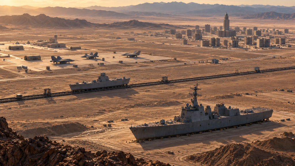
In the middle of the Taklamakan Desert, nearly 3,000 kilometers from the sea, stands an American destroyer. Not a real one, of course, but its dimensions and overall shape are immediately recognizable: roughly 155 meters long, with a superstructure, mast, and features resembling radar equipment. Several dozen kilometers away runs a railway capable of carrying another ship-shaped target. Elsewhere in China, satellite imagery has revealed mock aircraft carriers, piers, F-35 and F-16 fighters, Patriot air-defense systems, and replicas of American and Taiwanese naval facilities. In Inner Mongolia, meanwhile, there are streets and buildings so similar to Taipei’s government district that Chinese state television showed Chinese troops storming a structure resembling Taiwan’s Presidential Office as far back as 2015.
Taken separately, each of these facilities can be explained by the ordinary logic of military training: weapons need targets, soldiers need training grounds. But when satellite imagery and reports from more than a decade are viewed together, a much more interesting pattern emerges. Chinese ranges have gradually evolved from simple geometric targets into physical representations of specific potential adversaries. Instead of a generic ship, an Arleigh Burke-class destroyer appears. Instead of an abstract airfield, there are aircraft types operated by the United States and its allies. Instead of an ordinary urban training block, there are streets matching the political center of Taipei. The real question, therefore, is not whether China has “built a future war in the desert,” but something much more practical: what does the Chinese military gain by reproducing targets with this level of specificity?
A Fleet That Will Never See the Sea
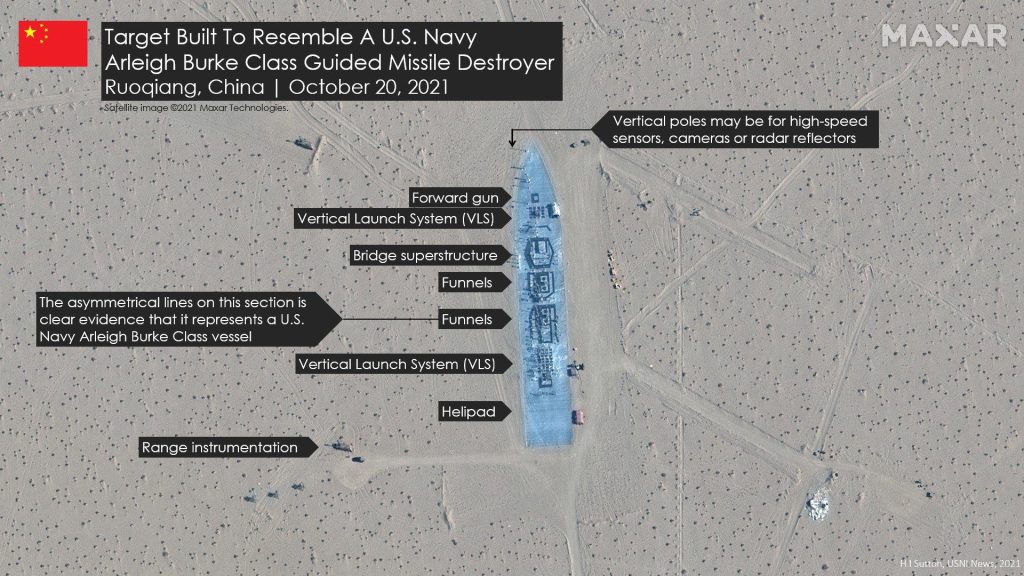
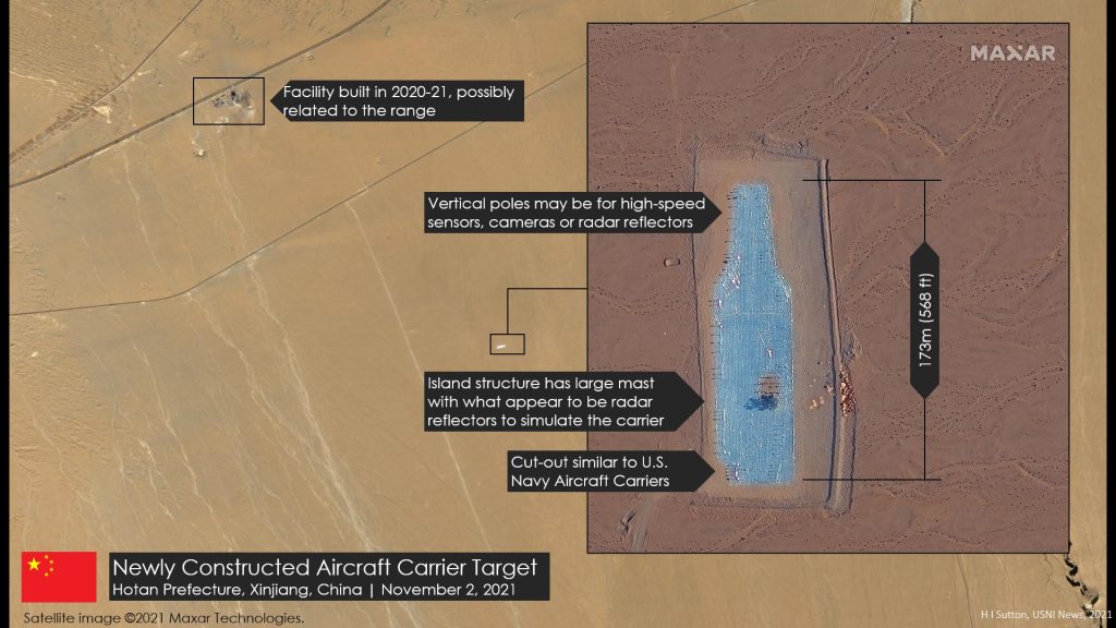
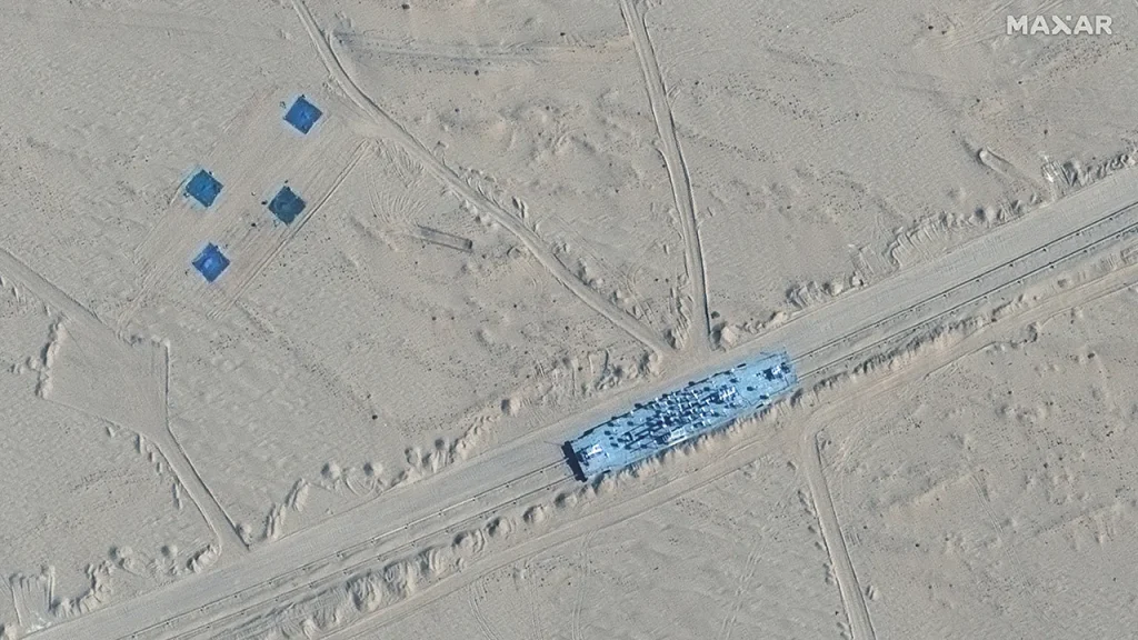
One of the best-known Chinese complexes of this kind lies near Ruoqiang in Xinjiang. It attracted widespread attention in November 2021, when USNI News published Maxar satellite imagery showing a full-scale outline of an American aircraft carrier, several targets roughly matching the size of Arleigh Burke-class destroyers, and an unusual wide-gauge railway carrying a ship-shaped target. Analysts immediately noticed that the site appeared more sophisticated than a simple missile range. Structures and equipment around the targets could potentially have been used for measurement, detection, and guidance testing.
The following year, it became clear that this was not an isolated facility. USNI identified several maritime target ranges along the eastern edge of the Taklamakan. One of the most interesting reproduced a ship alongside a full-scale pier. The structure appeared in late 2021; by February 2022, satellite imagery showed an impact almost directly on the ship target, after which the structure was dismantled. Another similar site existed roughly 300 kilometers away. The layout of the piers and the positioning of the “ships” were detailed enough for analysts to suggest that the purpose may have gone beyond simply measuring the accuracy of a ballistic missile. Such a range could also help test whether a weapon or guidance system can distinguish a ship from the surrounding infrastructure and select the intended target.
The concept itself is older. In 2017, former U.S. Navy submariner Thomas Shugart drew attention to Chinese missile ranges whose layouts resembled parts of American naval infrastructure in the western Pacific. Yokosuka, the principal U.S. naval base in Japan, was frequently mentioned in this context. Shugart cautiously suggested that Chinese missile forces might be practicing not only attacks on ships at sea, but also strikes on vessels while they are still in port.
Satellite imagery from 2026 appears to show the next step in this evolution. Instead of a flat outline, a full-scale three-dimensional mockup of an Arleigh Burke-class destroyer, roughly 155 meters long, appeared near Ruoqiang. It includes a superstructure, mast, and other large features that would affect how the target appears to various sensors. Nearby remains a roughly 23-mile, or 37-kilometer, rail system capable of moving a ship-shaped target. If the earlier ranges were satisfied with a rough silhouette, the newer target is far closer to a real vessel.
That evolution is arguably more interesting than the simple fact that there is “a destroyer in the desert.” If the only goal is to test whether a missile can hit a known point, a cross painted on the ground is sufficient. If the objective is merely to test detection, a comparatively simple radar target may be enough. But the more sophisticated terminal guidance becomes, the more useful a realistic target becomes. A modern anti-ship strike system must do more than receive approximate coordinates. It may need to detect an object, classify it, maintain track, and correct its trajectory during the final phase of flight.
The U.S. Department of Defense officially describes the DF-21D as a long-range anti-ship ballistic missile and states that the DF-26 also has a precision-strike role at ranges of several thousand kilometers. That does not mean that a particular Arleigh Burke mockup is necessarily intended for DF-21D or DF-26 testing; open-source evidence cannot establish that. But such a target offers a useful environment in which to test parts of the broader process—from detection to aim-point selection.
From Ships to Entire Naval Bases
If a single ship can be used to test a weapon against a specific target, the next logical step is to reproduce the environment surrounding that target. This is why facilities that analysts have compared with Yokosuka in Japan and Su’ao in Taiwan are especially noteworthy.
Reports based on 2026 Vantor satellite imagery identified target complexes whose pier arrangements resembled Yokosuka, where U.S. warships—including Arleigh Burke-class destroyers—are based. Other facilities were compared with Taiwan’s Su’ao naval base and included ship targets positioned alongside pier-like structures.
The logic becomes clearer here. Striking a ship at sea requires solving one extremely difficult problem: finding a moving object across a vast area of ocean. A ship in harbor is easier to locate, but creates a different challenge. It is surrounded by piers, buildings, other vessels, and objects with their own radar and infrared signatures. If a terminal guidance system is expected to select a particular ship from that clutter, a simple rectangle in the desert provides only a limited test.
A mock harbor can be much more useful than a mock aircraft carrier. It allows engineers to create neighboring and false targets, vary the position of objects, measure accuracy, and determine whether an algorithm can distinguish a ship from the pier next to it. USNI noted as early as 2022 that several Chinese sites followed this “pier plus ship” layout and that the materials used for the ship-shaped targets appeared different from the surrounding structures—possibly so that they would present different infrared or radar characteristics.
But the maritime ranges represent only one side of the story. Elsewhere in China, the military has built a completely different kind of training complex. There, instead of ships, it began reproducing streets.
The “Little Taipei” Has Existed for More Than a Decade
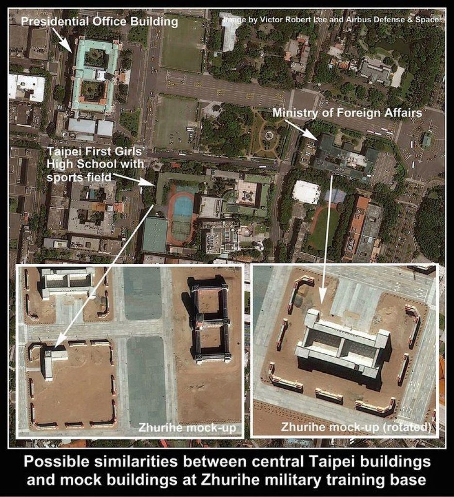
Zhurihe in Inner Mongolia is one of the Chinese Army’s largest training centers. In the mid-2010s, it became the source of one of the strangest images associated with Chinese military training. In July 2015, CCTV showed footage from the Stride-2015 exercises in which Chinese troops advanced on a five-story structure with a tower that was quickly identified as resembling Taiwan’s Presidential Office. Subsequent satellite imagery revealed additional structures nearby resembling government buildings and streets in central Taipei.
At first, the site could have been interpreted largely as a symbolic set piece—a recognizable building that made an exercise scenario immediately understandable. But the complex did not disappear. Instead, it continued to expand. A 2026 study published by Marine Corps University notes that Zhurihe now includes mockups resembling Taiwan’s Presidential Office and Ministry of Foreign Affairs, road junctions, and much more elaborate urban training areas with dense multi-story construction and courtyards. The authors regard this infrastructure as a strong indication that at least part of Chinese Army training is oriented toward the conditions of a potential operation involving Taiwan.
Zhurihe is not the only site of this kind. In 2024, satellite imagery of another range in Inner Mongolia attracted attention because its street layout closely resembled Taipei’s Bo’ai district, where the Presidential Office and other key government institutions are located. Taiwan’s then-defense minister Chiu Kuo-cheng confirmed that Taiwanese authorities were aware of such facilities, while also pointing out that creating mock versions of potential objectives is itself a common military practice.
The distinction between the two ranges is important. Zhurihe appears to place greater emphasis on buildings and the physical urban environment through which units can maneuver. The second site seems more focused on street geometry and block layout. It would therefore be misleading to describe them as one giant “fake Taipei.” A more accurate description is several ranges reproducing different elements of the same real-world environment for different training purposes.
Later satellite analysis also indicates that the Zhurihe complex continued to expand after 2020. This is also where a good example of how sensational claims can take on a life of their own emerged. Several 2026 reports claimed that a 280-kilometer underground tunnel system connected mock government buildings. That figure almost certainly resulted from an error in later reporting. The underlying Japanese and Taiwanese material refers to approximately 280 meters, not 280 kilometers. The difference matters: what exists is a large military training complex, not an underground replica of an entire capital region.
F-35s, Patriot, and a Japanese Aircraft in the Sand
Until recently, the maritime targets and “Little Taipei” could be viewed as two separate stories: one about missile testing, the other about ground-force training. Satellite imagery from 2026 added a third element.
In September, satellite imagery analyst Brady Africk published new Vantor images of a facility in Xinjiang that had been developed largely over the previous year. The site contains mockups resembling American F-35 and F-16 fighters, components resembling a Patriot air-defense system, and a much more specific target: a Boeing E-767 airborne early-warning aircraft, a type operated only by Japan.
Africk also pointed out that these particular targets did not appear to have been struck in the most recent imagery. It would therefore be incorrect to assume automatically that they were remnants of completed missile tests. They may instead be intended for future weapons trials, sensor calibration, target-recognition work, or other forms of training.
The E-767 is particularly revealing. An F-16 mockup could fit many scenarios because the aircraft is operated by numerous countries. Japan’s E-767, however, is unique to the Japan Air Self-Defense Force. That makes it much harder to treat the target as a generic stand-in for “enemy aviation.” At least some Chinese targets appear to be designed around very specific systems fielded by particular potential adversaries.
The same applies to the Arleigh Burke, Yokosuka, and the Taiwanese government district. The more such objects appear, the harder it becomes to explain them purely as generic training aids. That does not mean each mockup represents a finalized plan for a specific strike. Rather, they reveal which problems Chinese planners consider important enough to justify purpose-built training infrastructure.
Beijing rarely discusses the specific purpose of individual sites. When a Chinese Defense Ministry representative was directly asked in July 2026 about full-scale replicas of Taiwanese government facilities, the ministry did not confirm a specific operational scenario. Instead, it gave a broader answer: the Chinese military trains under conditions intended to approximate real combat and works to improve its readiness for war.
Taiwan’s Defense Ministry has likewise avoided claiming that a complete Chinese operational plan can be reconstructed from satellite imagery alone. In July 2026, it stated that facilities imitating Taiwan’s Presidential Office, government institutions, and naval bases, together with Chinese military activity around them, were being monitored by Taiwanese intelligence and taken into account in defensive planning.
Why Build the Opponent at Full Scale?
At first glance, the answer seems obvious: to shoot at it. But this is where the story becomes most interesting, because the different Chinese ranges appear to solve very different problems.
A flat aircraft-carrier outline can be used to assess general accuracy. A radar target can test a sensor. A ship moving on rails creates a tracking problem. A three-dimensional Arleigh Burke provides a target closer to the shape of the real vessel. A ship beside a pier introduces background clutter. Mock F-35s, Patriot systems, or an E-767 can be used for detection, recognition, and target-selection work. The urban areas at Zhurihe allow completely different units to repeatedly practice movement through the same intersection, obstacle clearance, infantry-armor coordination, or the seizure of a specific building.
What emerges is not a single “future-war range,” but an ecosystem of specialized training and test environments.
That is what separates the current picture from the first images of a Chinese “aircraft carrier in the desert.” Over the course of a decade, the targets have not merely multiplied. They have become more specific. The generic enemy has gradually acquired a particular class of warship, a recognizable superstructure, a particular aircraft type, a specific air-defense system, a particular naval base, and even street geometry familiar to the troops training there.
There is, however, an important limitation. Hitting an Arleigh Burke mockup standing in the desert is very different from hitting a real destroyer in the Pacific. A real ship maneuvers, employs electronic warfare, operates as part of a larger force, and attempts to intercept incoming weapons. More importantly, it first has to be found, classified, tracked, and linked to the weapon through a functioning targeting network. A range can test parts of that system, but a satellite image cannot prove that the entire kill chain would work reliably in combat.
The same is true of Taipei. A street can be reproduced to within a few meters and a unit can rehearse moving through it hundreds of times. What cannot be reproduced perfectly is a living city with civilians, destruction, disrupted communications, improvised obstacles, and an enemy constantly changing its actions. The mockups therefore do not prove that such an operation will happen, or that it would succeed.
What they do show rather clearly is which problems the Chinese military wants to practice solving in advance.
And that may be the most revealing part of the story. The most interesting Chinese military facility today may not be a new aircraft carrier or a new missile. It may be a desert where the potential adversary is gradually ceasing to be a circle on a map. Instead, it is given the length of a real warship, the silhouette of a real aircraft, the geometry of a real pier, and the layout of a familiar city intersection.
China has not built a copy of a future war in the desert. But it is clearly building increasingly realistic stages on which individual parts of such a conflict can be rehearsed again and again.